Sedona, Arizona Hikes With The Best Views
If you’ve read any of my other Arizona posts, it’s probably no secret Sedona is one of my favorite places in the USA. The red rocks, the energy, and the small-town charm.
Not only does the town have a cool vibe, some of the best hikes can be found in this red rock paradise. Whether you’re a beginner or seasoned trekker, there’s a Sedona trail calling your name. This is a list of some moderate, short but steep Sedona hikes.
This post may contain affiliate links. Please read my disclosure policy. If you purchase after clicking an affiliate link we may receive small commission at no cost to you. As an Amazon Associate I earn from qualifying purchases
Directions to Sedona Hikes
Great hikes can be found throughout the entire Sedona area. We divided the hikes based on the part of town they can be found in using the “Y” roundabout where Highway 179 meets 89A as our compass point. This main roundabout is a great landmark for planning your hikes.
- The Village of Oak Creek is found on 179 south of the “Y”
- West Sedona is west 89A, left of the “Y”
- Uptown Sedona is north 89A, right of the “Y.”
If you’re driving from Phoenix on Interstate 17 you will enter the Red Rock area via 179 and the Village of Oak Creek will be your first stop.
Moderate Hikes Near the Village of Oak Creek
On your way into Red Rock country stop at the Visitor Center to pick up any maps and Red Rock passes you will need.
Before hitting the trails, swing by the Red Rock Ranger Station Visitor Center to grab a map and your Red Rock Pass or American the Beautiful Pass. This area gives you an amazing intro to the Sedona landscape
Cathedral Rock Trailhead
There are so many beautiful hikes in Sedona it is hard to choose a favorite, but the Cathedral Rock trailhead has amazing panoramic views. The hike is relatively easy, but there is some rock scrambling on this hike.
- Distance: 1.4 miles round-trip
- Elevation gain: 600 ft
- Fee: Yes, this is a fee site. Use a Red Rock Pass or America the Beautiful Pass.
- Parking: From Thursday through Sunday Soldier’s Pass trailhead requires you to use the free Sedona shuttle.

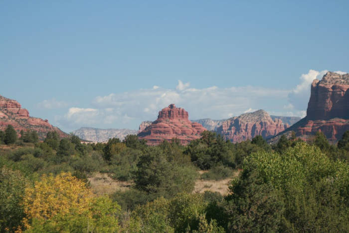
Broken Arrow
Views from Broken Arrow trail
West Sedona Arizona Hikes
Once you head west from the “Y” on 89A, you’re in West Sedona territory. This area is home to some of the big-name popular hikes. Hikes with trails west of Sedona’s “Y” intersection include:
- Seven Sacred Pools & Soldier’s Pass
- Devil’s Bridge
- Thunder Mountain
- Chimney Rock
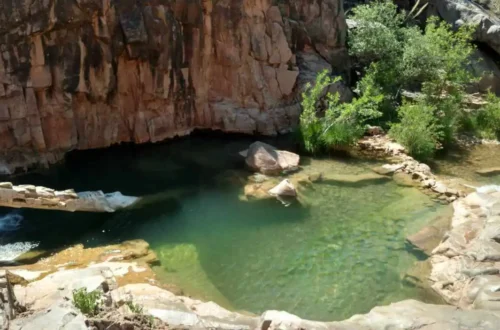
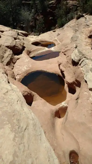
Seven Sacred Pools & Soldier’s Pass Sedona Arizona hikes
This trail has it all vortex energy, natural pools, a sinkhole, and red rock scenery.
- Distance: 4.8 miles round-trip
- Elevation gain: 450 ft
- Fee: Yes, this is a fee site. Use a Red Rock Pass or America the Beautiful Pass.
- Parking: From Thursday through Sunday Soldier’s Pass trailhead requires you to use the free Sedona shuttle.
Devil’s Bridge Trail
Devil’s Bridge is a fantastic hike. One of my favorite hikes in the Sedona area. Unfortunately, it is also a favorite of many so it is a busy hiking trail. From the trail head the hike is just under 2 miles round trip. Views from the natural sandstone arch is jaw dropping. Parking is tricky, and depending on where you start, the hike could be anywhere from 2 to 4 miles round-trip.
- Distance: 1.8 – 4 miles round-trip
- Elevation gain: 400 ft
- Fee: Yes

Birthing Cave in Sedona
The Birthing Cave is more of a hidden gem. A short, easy trail leads to a cave with an unforgettable view. You’ll need to park at the Long Canyon Trailhead.
- Distance: 2 miles round-trip
- Fee: No fee

Uptown Sedona Arizona Stunning Hikes
Heading north of the Y on 89A through uptown Sedona, you’ll enter lush canyon country. This area is leads you to some beautiful hikes along Oak Creek Canyon. Some of our favorite hikes in this area include:
Midgley Bridge
Midgley Bridge is a short hike near it’s namesake, Midgley Bridge. Parking is very limited. Park by the bridge and wander along the trails with views of Wilson Mountain and Oak Creek. If you are coming from uptown Sedona parking is directly to your left after you cross the bridge.
- Distance: 0.8 miles round-trip
- Elevation gain: 200 ft
- Fee: Yes, this is a fee site. Use a Red Rock Pass or America the Beautiful Pass.

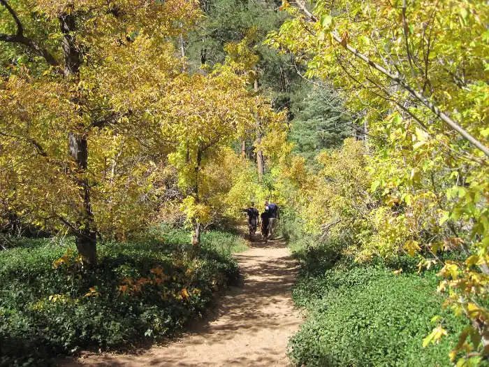
West Fork Trail – Call of the Canyon
This is hands-down one of the most beautiful hikes in Arizona, especially in the fall. Expect red rock cliffs, tall pines, and dozens of creek crossings. One of the most colorful fall hiking trails in Arizona, West Fork Trail is just north of Sedona in Oak Creek. It is our favorite spot to see the changing colors of the leaves.
- Distance: 7 miles round-trip
- Elevation gain: 230 ft
- Fee: Yes, this is a fee site. As of 2024, it is a $12.00 fee. You cannot use your Red Rock Pass or America the Beautiful pass here.
Sedona Hiking Tips
Here’s what I always tell friends and remind myself:
- Get there early. Parking fills up fast, especially on weekends. Some trails require you to take the Sedona Shuttle.
- Bring plenty of water.
- Wear trail shoes with good grip. Sedona trails can be rocky and slippery.
- A Red Rock Pass is required at many trailheads. You can get one at visitor centers or kiosks (most take credit cards).
- Dogs are welcome on many trails, but they must be leashed and always pack out your waste!
First Time Visitor to Sedona? Check out our blog post on An Essential Guide to Sedona Arizona for First Time Visitors
- Book a Flight to Sedona: To Sedona the closest airport is Flagstaff Pulliam and Sky Harbor in Phoenix.
- Rent a Car to Sedona: You can rent a car in Flagstaff or Phoenix and drive to Sedona. Alternatively, you can leave the driving to someone else and take a bus tour from Phoenix to Sedona.
- Where to Stay in Sedona: Choose from hotels, motels, resorts, airbnb, vrbo, cabins, and camp sites in Sedona.
- Tours to Take in Sedona
For fee sites you may need a Red Rock Pass or America the Beautiful Pass. You can purchase at the Sedona Chamber of Commerce or Oak Creek visitor center. Alternatively you can purchase a pass at the trailhead kiosk (credit cards only).