Tonto Natural Bridge – Explore the Largest Natural Travertine Bridge
There’s something magical about stumbling on a lush oasis tucked away in the middle of Arizona’s wild terrain, especially when that oasis includes the world’s largest natural travertine bridge.
Just two hours from Phoenix, Tonto Natural Bridge State Park in Payson is is home to one of Arizona’s most treasured spots.
Our kids absolutely love it here. It’s one of those family-friendly adventures where they can scramble over rocks, splash in shallow water, and let their imaginations run wild while we soak up the views.
This post may contain affiliate links. Please read my disclosure policy.
Tonto Natural Bridge
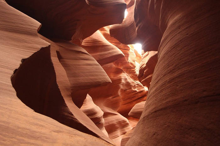
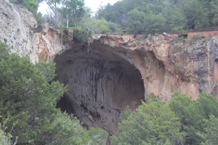
The highlight of the park is the 183-foot high travertine arch that stretches across a 400-foot long tunnel measuring 150 feet at its widest point.
You can walk on top of it, admire it from above, or take a hike down into the canyon and explore underneath, where hidden caves, waterfalls, and green moss-covered boulders await.
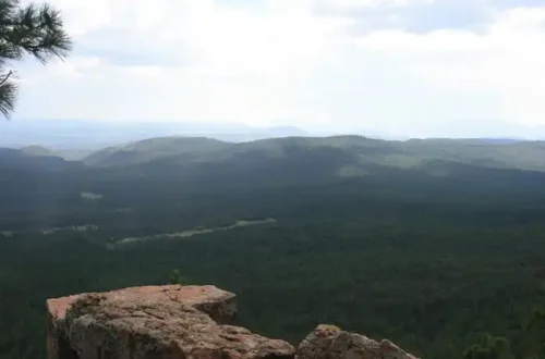
The Tonto Natural Bridge State park is 10 miles north of Payson, surrounded by the Tonto National Forest.
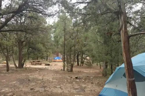
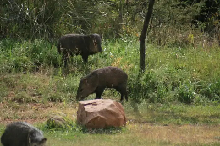
If you’re like us and live in the desert, any hike that ends at water is a gift. Add a picnic, javelinas and multiple scenic viewpoints, and you’ve got the perfect nature getaway.
Where is Tonto Natural Bridge State Park & How to Get There
This unique Arizona park is in Payson. From Phoenix it is a 2-hour drive to the park. Take Interstate 10 East towards Tucson and get off the exit to 202 East. Drive 12 miles , take exit 13 towards 87 North for 1/2 mile then you will need to be in the left lane to follow 87 to Payson.
Follow this road into Payson eventually it will turn into 260. After 75 miles you will take a left on NF 583 and drive into the park. There will be a large sign on your left for the entrance to the park. Map from Phoenix to Tonto Natural Bridge State Park.
Fees and Parking
There is a per person admission fee or you can use your Arizona state park pass if you have one. The parking lot is paved, and there are clean restrooms, picnic areas, and shady spots perfect for relaxing after your hike.
For the most up-to-date information please visit: Arizona State Parks
Tonto Natural Bridge State Park
The park is surround by national forest and all hikes lead to water, which is a treat in itself when living in the desert.
Viewpoints at the Park
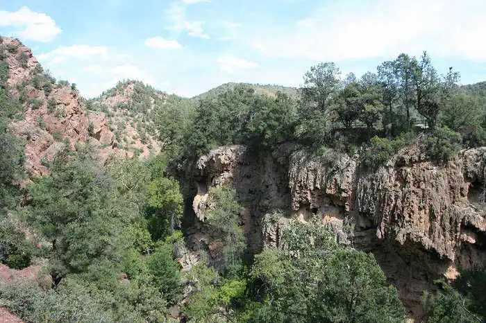
Even if you’re not a big hiker, you can still enjoy spectacular views. There are four main viewpoints throughout the park where you can see the bridge from above.
Viewpoints 3 and 4 are especially easy to access and don’t require any hiking. Just a short walk across a little creek, and boom you’re treated to a panoramic view of the arch, the waterfall, and, if you’re lucky, a rainbow stretching across the mist.
Viewpoints 3 & 4 – View without the Hike
If you want to see the Tonto Natural Bridge no hiking involved you can check out Viewpoint 3 & 4. The last parking lot will put you close to the trail.
You will walk across a small creek, one that could be easily overlooked but take note as this same water flows down from the top of Tonto Bridge.
From this viewpoint you can view the top of Tonto Bridge and the waterfall. And if you are lucky a rainbow too! Now that you’ve seen the top, take the Gowan trail hike to see it up close!
If you want to see the bridge up close and hike around underneath it the best trail to take is the Gowan trail.
4 Hiking Trails at the Park
All four official trails are under half a mile. Don’t let the short distance fool you some of them are steep, slippery, and rocky. Bring water and wear appropriate footwear. Tonto Natural Bridge State Park has four hiking trails to choose from.
- Gowan Hiking Trail
- Anna Mae Trail
- Waterfall Trail
- Pine Creek Trail
Gowan Hiking Trail
Gowan Trail is the longest, steepest, and most popular trail in the park. This is the one to do if you want to stand beneath the bridge and feel the cool mist of the waterfall.
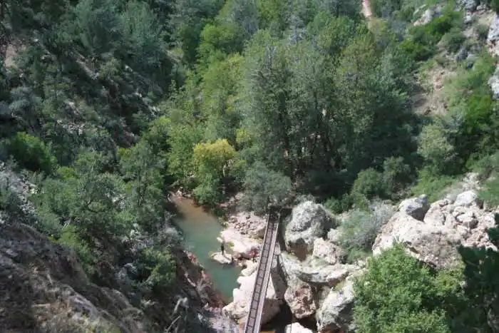
Drive to the last parking lot and you will see that the path starts out as a wide dirt path. The path is steep but it starts out wide, as it narrows you will walk down some stairs.
After the stairs the path is narrow and dirt. you can now see the water below you from above. A little while longer and you will reach the bridge. You can see the first glimpse of water below. Turn to your right to follow the creek, or walk onto the bridge that leads to the natural bridge and waterfall.
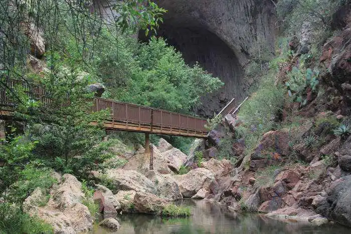
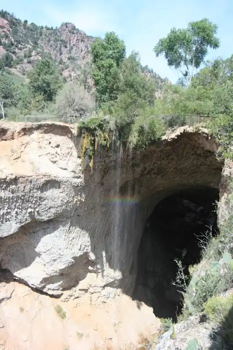
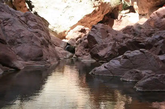
Before long, you’re standing at the bottom of the world’s largest natural travertine bridge. If the wind hits right you can feel the splash of the waterfall. Walk down the stairs and explore under the bridge!
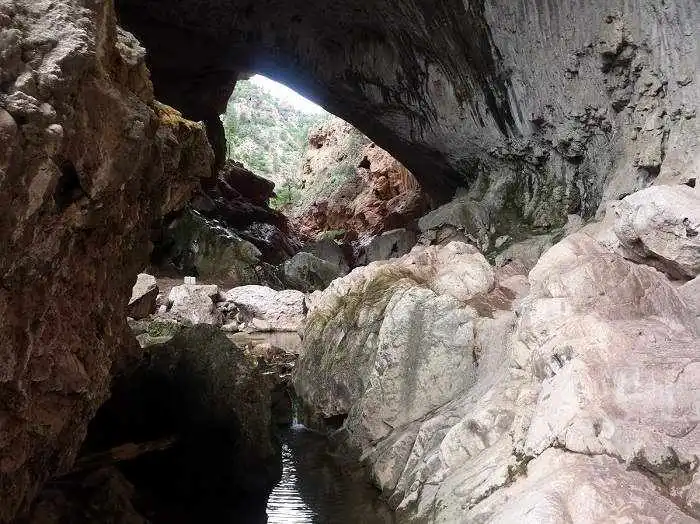
The best part of the hike is exploring under the bridge. You cannot walk directly under the waterfall, but you can walk along the rocks to the side and then behind the waterfall. The bridge is just over 180 feet tall and the tunnel is 400 feet long.
There are pools of water and small waterfalls splashing over rocks underneath the bridge. Look up you might spot the caves where David Gowan, a Scottish prospector, reportedly hid from Apaches in 1877. Later he claimed squatter rights on the land.
You almost will feel like you are entering a secret grotto when going from the bright light outside into the filtered light which feels somewhat like exploring a cave. Under the bridge there are many pools of water.
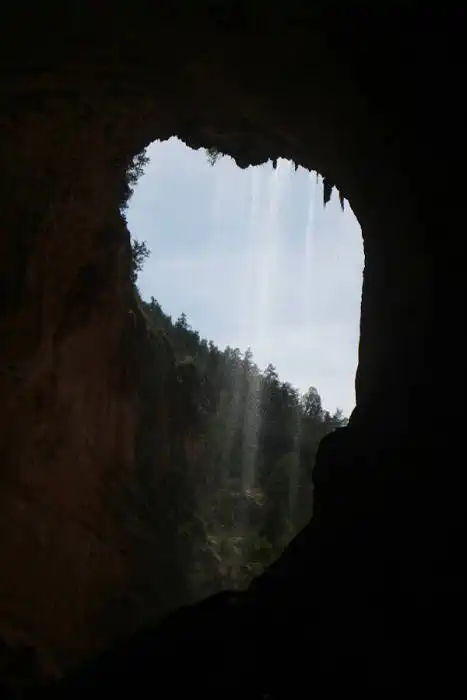
Looking back you can see the waterfall from behind streaming down the rock and hitting the mossy boulders below. It is almost prettier from this view. You can then take the Anna Mae trail back up to the parking lot area from here.
Anna Mae Trail at Tonto Natural Bridge
The Anna Mae Trail is a steep dirt path that will wind down to the back side of the Tonto Bridge waterfall or if you took the Gowan trail down to the bridge you can take the Anna Mae trail back up to the parking lot.
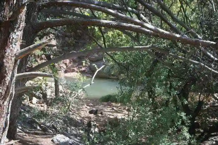
The views from the trail are incredible rock formations and caves. You will make a right turn as you descent into nearby boulders and pools of water.
This trail has some neat small pools of water surrounded by huge boulders and lush trees. The Anna Mae trail is a short hike to reach the back side of the Tonto Natural Bridge.
Hike Waterfall Trail
At a distance of just 300 feet this trail is short, but it packs a visual punch. It starts out steep with uneven stairs and ends at a small, shaded area of trickling water. Be careful on the rocks, especially near the end because it’s slippery.
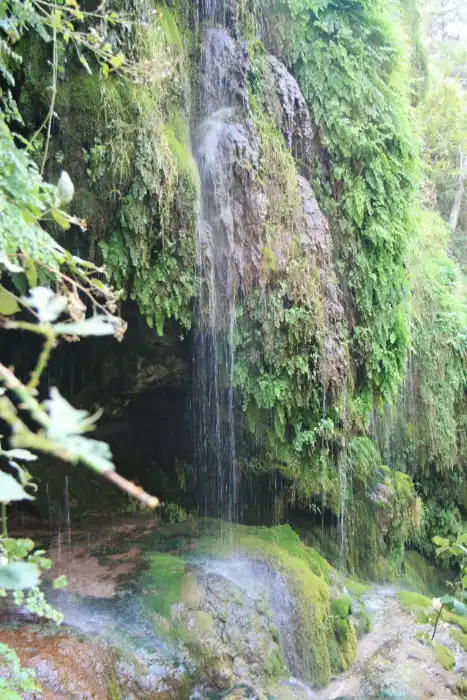
This is one of those hikes where you just stop and let the moment soak in. The mossy cave, the sound of water dripping onto stone, and the play of light and shadow make it feel like you’ve found a hidden pocket.
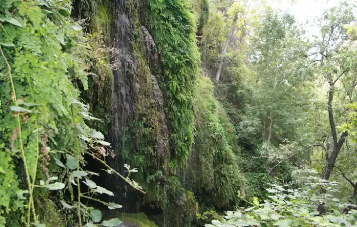
Pine Creek Trail
Another short trail with a rugged path that runs along the creek. It’s best for those looking to explore more of the canyon floor.
Pictures really do not do this park justice, you have to see it in person. The waterfall at the end of the trail is enchanting. The water falls in a steady stream, cascading off of moss covered rocks, peeking past the waterfall you can see the wet cool cave. Lichen covers the large boulders and the inside of the watery cave.
Picnics & Wildlife
After your hike, grab a spot at one of the shady picnic tables. We had lunch while watching a group of javelinas snuffle through the brush nearby. It’s those little moments that make this park so special.
If you’re already planning a trip to Payson, this stop is a must. And if you’re not? Well, this park alone might be worth making the trip.
To learn more about Payson, check out our post on Exploring the “Heart” of Arizona.
Phone: (928) 476-4202
Address: P.O. Box 1245 Payson, AZ 85547
Directions: from Phoenix take the Beeline Hwy (State Route 87) to Payson, 10 miles north of Payson turn left on US forest 583