
The Grand Canyon: See the Greatest Canyon & Arizona’s Natural Wonder
When people around the world hear “Arizona ,” the first thing that usually pops into their minds is the Grand Canyon. It lives up to every bit of the hype.
Tucked away in the northwest corner of the state, about 250 miles from Phoenix, the Grand Canyon feels like another planet entirely. One minute you’re cruising through the desert under wide-open skies, and the next, you’re standing at the edge of one of the most jaw-dropping sights you’ll ever see. It’s no surprise this place made the cut as one of the Seven Natural Wonders of the World.
The mighty Colorado River, along with millions of years of time, carved out this incredible masterpiece, layer by stunning layer. If you’re lucky enough to have a few days to spend here, trust me, you’ll barely scratch the surface.
The Grand Canyon isn’t just one big overlook it’s: scenic drives, peaceful hikes, sunrise vistas that will leave you speechless, little hidden corners where it feels like you’re the only person on earth, and amazing memories.
This post may contain affiliate links. Please read my disclosure policy.
Even if you can only swing a day or two, go. Pack your walking shoes, toss a few extra layers in your bag (because yes, the weather changes fast up there!), and just go.
There’s something about seeing the Grand Canyon or any of the National Parks with your own eyes that no photo, no documentary, and no story can ever truly capture.
Grand Canyon National Park Overview
The Grand Canyon’s main tourist attraction is the south rim. To hike to the north rim it is about 10 miles from the south rim to drive it will take you about 4.5 hours. Its sheer size and colorful landscape, makes it an adventurous place to explore. To access the south rim from Phoenix the drive is 220 miles. Take Interstate 17 north to Flagstaff for 150 miles, From Flagstaff the drive is around 75 miles.
- Where is the Grand Canyon & How to Get There
- Grand Canyon Map
- Things You Need to Know
- How to Get Around the Grand Canyon
- What is the Weather like in the Grand Canyon?
- Grand Canyon South Rim
- Where to Stay Near the Grand Canyon
- Grand Canyon North Rim
- How deep is the Grand Canyon?
- How long does it take to see?
Where is the Grand Canyon & How to Get There
The Grand Canyon National Park is in the northwest region of Arizona.
You may be surprised to learn there are three entrances to the Grand Canyon National Park:
- South Rim: The south rim is the main park entrance. South Rim map
- East Entrance or Desert View:
- North Rim: The north rim is open seasonally (usually mid-May to mid-October). North Rim map
- As of 2025 reservations are not required to enter the National Park, there is no timed entry.
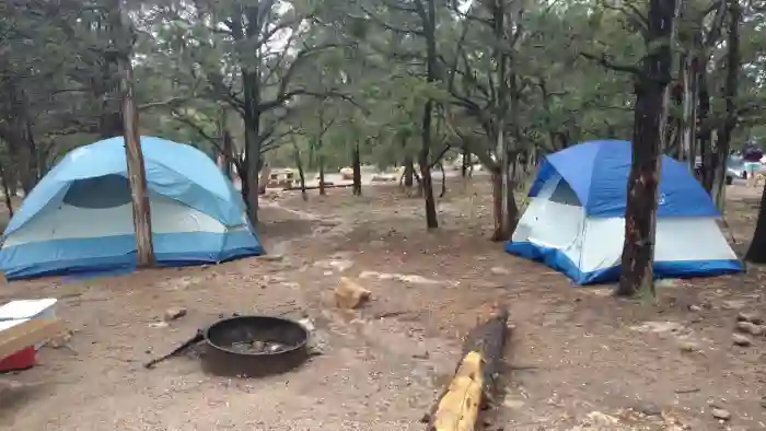
- Reservations are required to camp at the Grand Canyon.
What does it cost?
A 7-day pass to the National Park will cost you $35.00 (for a private car) as of 2025. This pass is good for both the South Rim and North Rim (mid-May to mid-October). Only credit/debit card is accepted. You can also purchase a Grand Canyon annual pass or an America the Beautiful annual pass.
Grand Canyon
The south rim is were 90 percent of visitors will explore what the canyon has to offer. It is the main park entrance.
Five Main Areas of the Grand Canyon South Rim
- Visitor Center
- Market Plaza
- Village
- Hermit’s Rest (west)
- Desert View (east)
Getting Around the Grand Canyon
There are several FREE shuttle bus routes at the South Rim:
- Hermit’s Rest Route (red line)
- Village Route (blue line)
- Kaibab Trail Route (orange line).
- Tusayan Park & Ride (purple line) – only open in the summer.
Itineraries
- 1-day Itinerary
- 2-3 day Itinerary
Grand Canyon Visitor Center & Rim Trail
As soon as you roll through the South Entrance of Grand Canyon National Park, your very first stop?
The Grand Canyon Visitor Center. It pops up almost right away, and trust me, it’s worth pulling over. It’s the perfect spot to grab a map, get your bearings, and figure out your game plan for the day.
You’ve got a few awesome options, all starting right here:
- Lace up your sneakers and hit the Rim Trail. This trail hugs the edge of the canyon, and it’s mostly flat and paved near the Visitor Center, making it an easy stroll no matter your pace.
- Rent a bike and cruise the trails like a pro.
- Hop on a free shuttle bus. The orange and blue lines whisk you straight to some of the best viewpoints without the parking hassle.
First Big WOW at the Grand Canyon
From the Visitor Center, it’s a short, easy walk, about a third of a mile, to Mather Point. Here is where the Grand Canyon really shows off. This is where most visitors get their very first jaw-dropping look at the Grand Canyon. Trust me, you’ll want to have your camera ready. The canyon stretches out in layers of red, orange, and gold that seem to go on forever.

If you’ve got a little extra time keep walking west along the Rim Trail. This stretch is one of the easiest and most rewarding walks in the park. About a mile from Mather Point, you’ll reach Yavapai Point and the Geology Museum. This spot is a hidden gem.
Yavapai Point & Geology Museum
Inside the museum, you’ll find huge floor-to-ceiling glass windows with panoramic canyon views. It’s the perfect place to really see the story of the canyon. Learn how the rock layers formed over millions of years, what the different colors mean, and how the mighty Colorado River continues to shape it today.
The exhibits are super easy to follow , and the air-conditioning feels amazing if you’re visiting during warmer months.

Kaibab Rim Route – Orange Line Shuttle Bus
We took the Kaibab/Rim Route shuttle (orange line) from the Visitor’s Center to the South Kaibab Trail. Getting there early was the key. The bus was not crowded and the path is shaded in the morning. If you’ve never taken a shuttle at the Grand Canyon before, don’t worry it’s super easy. They’re clearly marked, they run often, and best of all, they’re free! Just hop on and let someone else do the driving while you enjoy the view. This bus will take you to the following points of interest:
- South Kaibab Trail (eastbound)
- Pipe Creek Overlook (westbound)
- Mather Point (westbound)
- Yavapai Geology Museum (westbound)
- Yaki Point (eastbound)
- Visitor Center
Hiking in the Grand Canyon is amazing. Just remember lots of water and salty snacks. Before you even set foot on the trail: Pack more water than you think you’ll need. The Grand Canyon is sneaky it heats up fast as the day goes on. Salty snacks are a must. Think trail mix, pretzels, or even a few handfuls of nuts. Salt helps your body hang onto the water you’re drinking.
Friendly reminder: There’s no water available on the South Kaibab Trail itself so come prepared!
The South Kaibab trail starts off with steep switchbacks. Even if you’re not planning to hike all the way to the bottom the South Kaibab Trail offers some of the most stunning canyon views with just a short hike.

The hike to Ooh Ahh Point is just under two miles round-trip and it’s absolutely worth the trek.
The name says it all. The first time you step out onto that ledge and look around, it’s all “oohs” and “aahs”. The views are stunning.

After hiking you can take the shuttle back to the Visitor’s center where your car is parked.
Market Plaza (Blue Route)
Just west of the Visitor’s center is the Grand Canyon Market Plaza area. It’s like a mini town center.
Need to send a postcard home? There’s a post office here. Need to grab some extra cash? There’s a bank too. And the real star of the show? The Grand Canyon General Store, which is a lifesaver if you’ve forgotten anything. Snacks, sunscreen, hiking socks, souvenirs… you name it, they probably have it .
Market Plaza is also super convenient if you’re camping at Mather Campground. We were able to walk down a short path from our tent site to the plaza. Keep your eyes open as you stroll through this area!
We spot several elk just grazing including a baby elk.

The Village (Blue Route)
The train depot for Williams is on the way west towards the Village. The Village is where the majority of lodges are located including the famous Bright Angel Lodge, El Tovar Hotel, Hopi House and Verkamp’s Visitor Center. From here visitors can catch the red and blue line shuttle bus. The Bright Angel Trail is located in this area. This trail is extremely popular.
From Market Plaza, we keep heading west and pretty soon we pass the historic Grand Canyon Railway Depot. If you’re coming via train from Williams, this is where the old-fashioned train drops visitors off.
Not much farther and we arrive at the Village, which is the heart of the South Rim.
This is where most of the famous historic lodges are, including:
- Bright Angel Lodge — cozy and rustic, full of charm
- El Tovar Hotel — elegant and iconic, with serious Old West vibes
- Hopi House — a beautiful spot for authentic Native American arts and crafts
- Verkamp’s Visitor Center — a great place to dig into the canyon’s history

The points to the west of the Village towards Hermit’s Rest can only be accessed by walking the Rim Trail or by taking a shuttle bus. Needless to say, the earlier you catch the shuttle bus the less people you will encounter.
Hermit’s Rest – West of the South Rim
Catch the red line shuttle bus just past Bright Angel Lodge to see the stops on the west side of the canyon. There are nine stops along this route. The bus ride is 80 minutes long if you do not get off at any of the stops.
Hopi Point stop juts out farther into the canyon and offers great views of the Colorado River. We visited this stop during the rainy season, so the water looked like mud.

Hermit’s Rest is the final stop on the shuttle bus and leads to the trail head. This is also the only spot on the route with a water station, gift shop and place to purchase snacks and drinks.

Hermit’s Rest was opened in 1914 as a rest house. Visitors were brought by horse and buggy. Mary Colter designed Hermit’s Rest, which has now been converted into a gift shop. Stop in and check it out if you are out this way.

Desert View Drive
For a little less congestion drive east on Desert View Drive for the next 23 miles. The free shuttle bus only come this way in the summer, so if you are visiting at another time of year and want to see the east side of the canyon you’ll need a car. This side of the canyon, in my opinion, is better because there are less people.
Viewing Spots Include:
- Yaki Point (this is the only point on Desert View Drive that can be accessed via the shuttle)
- Grandview Point
- Moran Point
- Tusayan Ruin and Museum
- Lipan Point
- Navajo Point
- Desert View Point & Desert View Watchtower
How deep is the Grand Canyon?
This impressive canyon is not the deepest canyon in the world, but at 1 mile deep, 18 miles wide and 277 miles long it is one huge canyon!
The South Rim is at a 7,000 foot elevation and the North Rim is close to 9,000 feet in elevation.
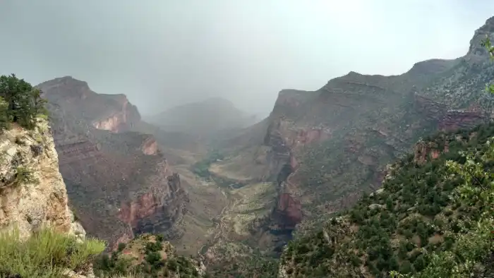
Weather in the Grand Canyon
- Spring and fall can be much cooler than it is in Phoenix, so layering your clothing is a good idea.
- Summers are pleasant. Monsoon season is in July, August, and the beginning of September. If you visit during these months it is not uncommon to experience heavy rain.
- Winter is much cooler and it is impossible to view the North Rim during the winter months as the roads will start to close mid October due to snow.
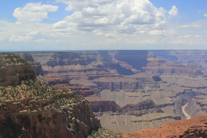
How Long does it Take to See?
In a nutshell, as long as you want it to. You could spend the day there or your entire vacation. A visit to the Grand Canyon can be a weekend trip or a destination in itself. View the canyon, hike the many trails, go rafting on the Colorado River, view waterfalls, whatever you choose to do-enjoy the nature that surrounds you!.
If you are staying in northern Arizona, the Grand Canyon is a wonderful spot to spend a few days and truly enjoy the views and the many trails.
To drive from the South Rim to the East Rim is close to 25 miles one way.
We suggest visiting the Grand Canyon National Park’s web site for up to date information on weather and road closures before you begin your journey to visit the Grand Canyon.
